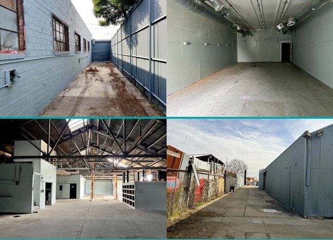
Property Record
1215 High St, Oakland, CA 94601
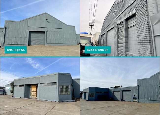
This Property Is For Sale
Current Lease Availabilities
NEARBY LISTINGS FOR SALE OR LEASE
Property Detail
1215 High St
Oakland-Hayward-Berkeley, CA
Sather
033-2153-017-03
LOT: 00002 BLK: 0007 AR: 0033 PAGE: 2153 ;LOT: 00003 BLK: 0017 AR: 0033 PAGE: 2153 ;LOT: 0000B BLK: PM: 0091 PAGE: 0067
Autorepair
Alameda
X
California
06001C0089H
7
2024
0.41 AC
2025
Oakland
407200
East Bay/Oakland
6,600 SF
DEMOGRAPHICS near 1215 High St
1 Mile
3 Mile
5 Mile
2024 Total Population
37,299
263,189
490,222
2029 Population
35,842
254,039
475,567
Pop Growth 2024-2029
(3.91%)
(3.48%)
(2.99%)
Average Age
37
40
41
2024 Total Households
10,856
92,480
185,874
HH Growth 2024-2029
(4.11%)
(3.63%)
(3.02%)
Median Household Inc
$59,149
$82,490
$90,741
Avg Household Size
3.10
2.70
2.50
2024 Avg HH Vehicles
2.00
2.00
2.00
Median Home Value
$687,285
$872,372
$915,226
Median Year Built
1948
1949
1955
Nearby Places
Map Layers
Map Styles
 Street
 Aerial
- Restaurants
- Banks
- Shops
- Fitness
- Groceries
PUBLIC TRANSPORTATION
TRANSIT/SUBWAY
Fruitvale Station (Dublin/Pleasanton - Millbrae - Bay Area Rapid Transit (BART), Fremont - Daly City - Bay Area Rapid Transit (BART), Fremont - Richmond - Bay Area Rapid Transit (BART))
DRIVE
WALK
Distance
Fruitvale Station (Dublin/Pleasanton - Millbrae - Bay Area Rapid Transit (BART), Fremont - Daly City - Bay Area Rapid Transit (BART), Fremont - Richmond - Bay Area Rapid Transit (BART))
2 min
11 min
0.6 mi
COMMUTER RAIL
22nd Street (Caltrain - Caltrain (Caltrain))
DRIVE
WALK
Distance
22nd Street (Caltrain - Caltrain (Caltrain))
9 min
5.4 mi
AIRPORT
Metro Oakland International
DRIVE
WALK
Distance
Metro Oakland International
11 min
5.3 mi
San Francisco International
DRIVE
WALK
Distance
San Francisco International
33 min
27.3 mi
Freight Ports
Port of Oakland
DRIVE
WALK
Distance
Port of Oakland
1 min
3.8 mi
Nearby Properties
Address
Land Use
TOTAL SIZE
Lot Size
Zoning
Address
Land Use
TOTAL SIZE
Lot Size
Zoning
Address
Land Use
TOTAL SIZE
Lot Size
Zoning
546,164 SF
6.02 AC
Address
Land Use
TOTAL SIZE
Lot Size
Zoning
371,504 SF
4.08 AC
Address
Land Use
TOTAL SIZE
Lot Size
Zoning
534,208 SF
23.18 AC
Address
Land Use
TOTAL SIZE
Lot Size
Zoning
273,623 SF
1.44 AC
Address
Land Use
TOTAL SIZE
Lot Size
Zoning
297,617 SF
1.54 AC
Address
Land Use
TOTAL SIZE
Lot Size
Zoning
259,247 SF
5.44 AC
R5PD
Address
Land Use
TOTAL SIZE
Lot Size
Zoning
525,864 SF
16.53 AC
Address
Land Use
TOTAL SIZE
Lot Size
Zoning
180,959 SF
9.38 AC
Address
Land Use
TOTAL SIZE
Lot Size
Zoning
374,725 SF
18.63 AC
Address
Land Use
TOTAL SIZE
Lot Size
Zoning
336,680 SF
9.93 AC
M40
Address
Land Use
TOTAL SIZE
Lot Size
Zoning
133,636 SF
5.46 AC
Address
Land Use
TOTAL SIZE
Lot Size
Zoning
284,255 SF
5.07 AC
Address
Land Use
TOTAL SIZE
Lot Size
Zoning
320,001 SF
37.56 AC
Address
Land Use
TOTAL SIZE
Lot Size
Zoning
165,042 SF
13.50 AC
Address
Land Use
TOTAL SIZE
Lot Size
Zoning
169,558 SF
1.65 AC
Address
Land Use
TOTAL SIZE
Lot Size
Zoning
200,238 SF
9.28 AC
Address
Land Use
TOTAL SIZE
Lot Size
Zoning
Address
Land Use
TOTAL SIZE
Lot Size
Zoning
133,678 SF
4.33 AC
Address
Land Use
TOTAL SIZE
Lot Size
Zoning
155,000 SF
8.41 AC
Address
Land Use
TOTAL SIZE
Lot Size
Zoning
136,127 SF
8.21 AC
Address
Land Use
TOTAL SIZE
Lot Size
Zoning
232,068 SF
31.82 AC
Address
Land Use
TOTAL SIZE
Lot Size
Zoning
129,726 SF
5.38 AC
Address
Land Use
TOTAL SIZE
Lot Size
Zoning
0.94 AC
Address
Land Use
TOTAL SIZE
Lot Size
Zoning
197,321 SF
16.52 AC
Address
Land Use
TOTAL SIZE
Lot Size
Zoning
213,600 SF
10.60 AC
Address
Land Use
TOTAL SIZE
Lot Size
Zoning
1,189,534 SF
26.64 AC
Address
Land Use
TOTAL SIZE
Lot Size
Zoning
204,006 SF
6.39 AC
M40
Address
Land Use
TOTAL SIZE
Lot Size
Zoning
86,973 SF
2.92 AC
Address
Land Use
TOTAL SIZE
Lot Size
Zoning
165,638 SF
4.06 AC
The World's #1 Commercial Real Estate Marketplace
Connect with us
© 2025 CoStar Group
The information above has been obtained from sources believed reliable. While we do not doubt its accuracy we have not verified it and make no guarantee, warranty or representation about it. It is your responsibility to independently confirm its accuracy and completeness. Any projections, opinions, assumptions, or estimates used are for example only and do not represent the current or future performance of the property. The value of this transaction to you depends on tax and other factors which should be evaluated by your tax, financial, and legal advisors. You and your advisors should conduct a careful, independent investigation of the property to determine to your satisfaction the suitability of the property for your needs.